| Title | Roman Road |
| Date | Undated |
| Location | Carlton |
| Photo ID | A009 |
| Comment | Roman Road 72b ran Eastwards from Ilkley (Olicana) to Tadcaster (Calcaria), a distance of 24 miles. |
It’s course followed the Grove, Station Road, for 200 yards to Cow Pasture Gate, then by a line of fences and short stretches of road to Ben Rhydding House.
Beyond Ben Rhydding, on a hill above Boggart Wood, the agger (artificial elevation) is visible, 16 foot wide, following a path through a plantation near Wicken Tree Well, North-West of The Mount for 250 yards and on as a bridle path South of Low House.
It then passes through the grounds of Scalebor Park, (former hospital now housing) continuing on for a mile and a half to Gill Mill, then crossing Burley Moor Lane about 180 yards South of the station.
It crosses Menston Lane, North of the railway 350 yards from the junction with Burley New Road, then over this road South of the railway bridge.
There are no remains visible in this area.
The road climbs to the end of Otley Chevin where it has been damaged by quarrying but it can be seen about 70 yards further on.
It then runs through fields South of the ridge and North of Oaks Farm on a South-Easterly alignment which takes it just South of East Carlton, it is faintly visible on Guiseley Moor.
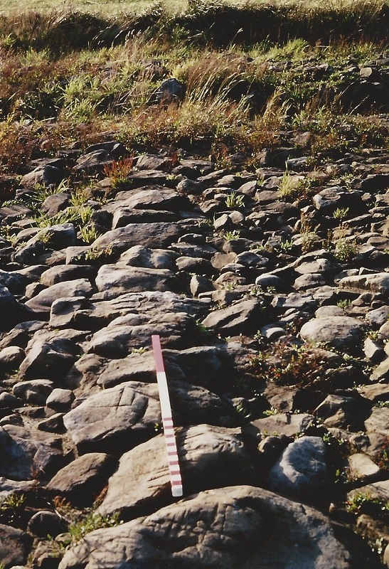
It was examined here and found to be intact, only 6 inches below the surface, 13 and a half foot wide, with rounded boulders as kerbs, composed of broken stones 1 foot deep.
Another later excavation nearby indicated a width of 17-21 feet with 4.5 inches of cobbles on 5 inches of rubble and clay but the surface layer was destroyed.
There was a kerb of large stones to the north side.
Traces of the agger were visible as far as the boundary of East Carlton Parish and near here was an uninscribed standing stone, possibly a milestone on the road.
From information held by Aireborough Historical Society, article dated 1958.
In this image the central spine of the road has been marked by ploughing, it had been covered by vegetation which accounts for the good state of preservation.
Carlton Categories

A008 – Roman Road, Undated.
Roman Road – Undated
Excavation by W.E.A. Class.
Tutor H. Bowes.
Roman Road.
Green Gates Farm.
Otley Old Road.
JH074 – Roman Road, 1979.
Roman Road – 1979
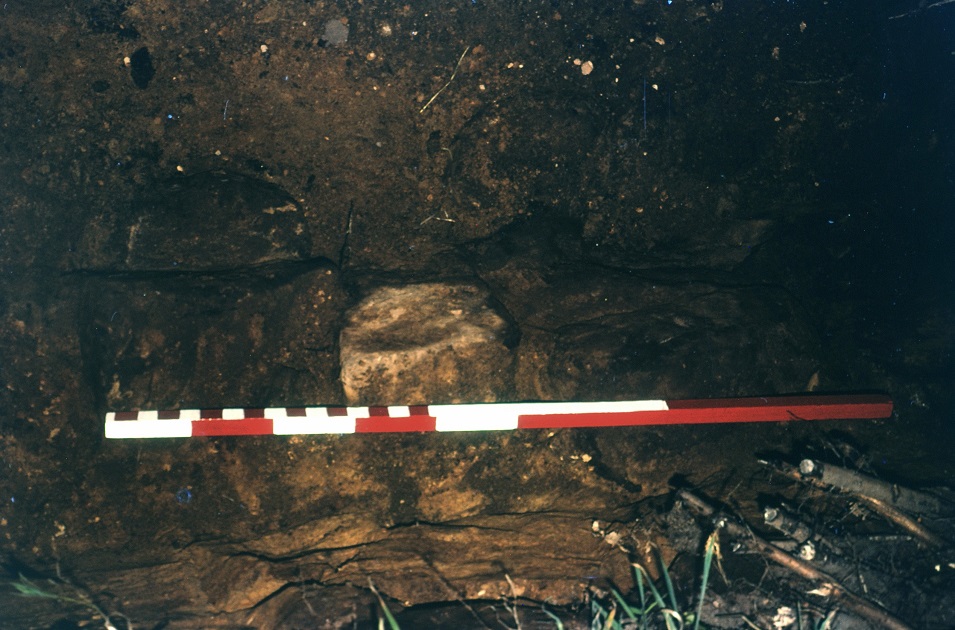
Kerb stones which were part of a Roman road which ran across Carlton Moor, they are sited beneath a hedge.
Image digitally transferred from a 35 mm slide by John Hobson.
Consolidated by Jack Brayshaw. 30 April 2021.
Last updated: 16 November 2022 – All images updated.