| Title | Multi-View Postcard |
| Date | 1906 |
| Location | Guiseley |
| Photo ID | B048 |
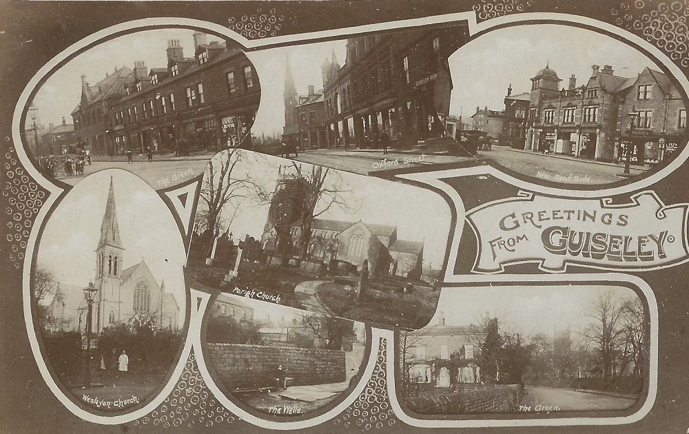
| Comment | Postcard with 7 images of Guiseley, top left is a view of The Green looking from the junction with Otley Road. The houses are part of Belle Vue Terrace, next is Guiseley Town Hall followed by a row of shops. Top centre is Oxford Street (continues into Oxford Road) looking in the direction of Otley Road. The spire of the Wesleyan Methodist Church dominates the sky line. Moving right, Butts Lane then Guiseley Co-op stores are first in the block of shop properties. The top right image is of Oxford Road at the junction with Otley Road. St. Oswald’s Church occupies the centre of the postcard, bottom left the Wesleyan Methodist Church on Oxford Road. Bottom centre, Guiseley Wells once the main water source for the town, now restored and still flowing. Another view of The Green is bottom right, this one is further up towards St. Oswald’s Church, the house is Greencroft. |
B048R – Multi-View Postcard, 1906.
Multi-View Postcard – 1906
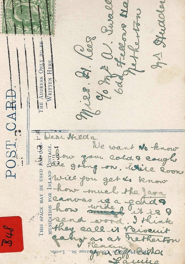
A message on the reverse Addressed to Miss H Lees c/o Mr A Swallow, Odd Fellows Hall, Netherton Nr. Huddersfield reads:
“Dear Hilda. We want to know how your cold & cough are getting on. Write soon. Will you get to know how much the Java Canvas is a yard & how wide it is and send word. I think they call it biscuit colour as at Netherton. Remain your aff. sister -?” It is addressed to Miss H Lees, Netherton Nr. Huddersfield.
Note: Arthur Swallow was Hilda’s cousin, the eldest male in the household. Hilda was a dressmaker aged 21 and living with the Swallow family in the 1911 census.
In the 1901 Census a Hilda Lees lived at 1 Well Road, Guiseley, with an older sister Fanny who is still at this address in the 1911 Census.
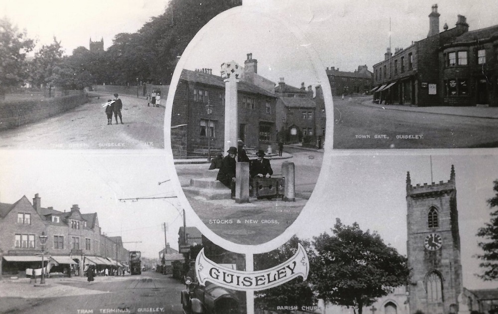
A407 – Multi-View Postcard, 1909.
Multi-View Postcard – 1909
In the top left is The Green, looking towards St. Oswald’s Church.
The top right corner is Town Gate with the New Inn on the right edge.
Bottom left, entitled Tram Terminus, is a view of Otley Road (A65) featuring one of the trams which terminated here at that time.
St. Oswald’s Parish Church bottom right.
In the centre is another Town Gate scene entitled the Stocks and New Cross.
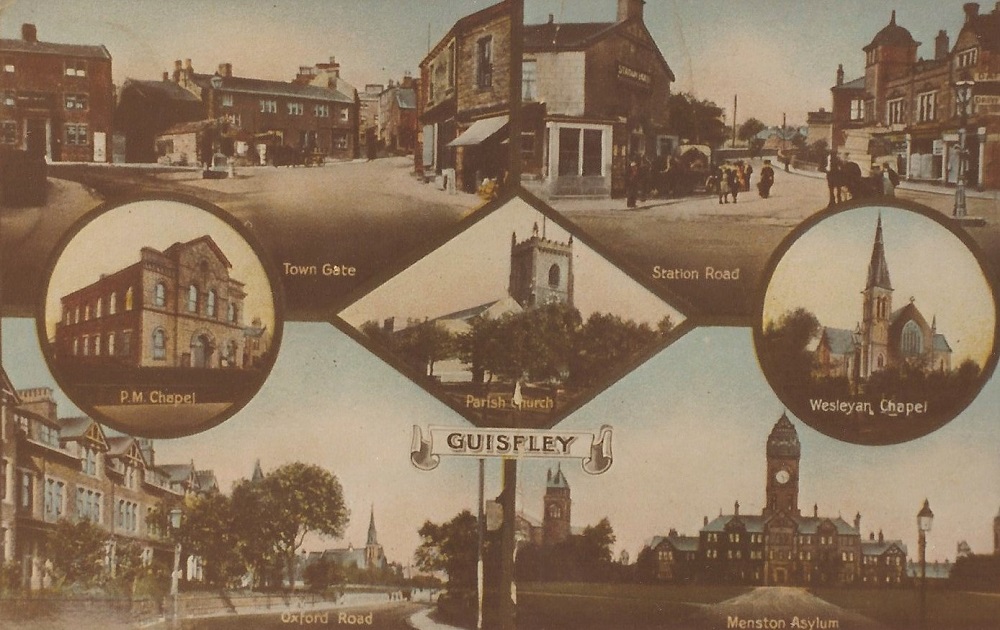
A377 – Multi-View Postcard, 1913.
Multi-View Postcard – 1913
Top left: A scene of Town Gate. Top right: Oxford Road seen from Otley Road (A65). Entitled Station Road.
Left circle: The Primitive Methodist Chapel. Central diamond: St. Oswald’s Church.
Right circle: The Wesleyan Methodist Chapel on Oxford Road. Bottom left: view of Oxford Road.
Bottom right: High Royd’s Hospital, Menston.
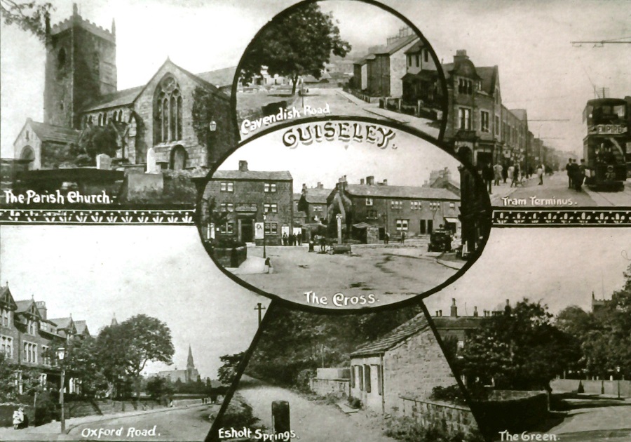
L269 – Multi-View Postcard, 1920s.
Multi-View Postcard – 1920s
In the centre is Town Gate with the cross and stocks, upper left shows St. Oswald’s Church, upper middle a view of Cavendish Road and the upper right picture shows a tram at the terminus on Otley Road. Bottom left has a view of Oxford Road, bottom middle is Esholt Springs, bottom right shows The Green with a glimpse of St. Oswald’s Church tower above the trees on the right.
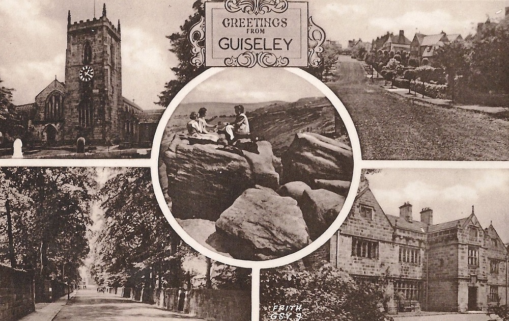
DD046 – Multi-View Postcard, 1940s.
Multi-View Postcard – 1940s
A postcard with 5 images of the area entitled Greetings from Guiseley. Top left: St. Oswald’s Church, Top right: houses on the Tranmere Park estate Bottom left: Park Road, Bottom right: The old Rectory, Centre: Part of a rock formation locally named the ‘frying-pan’ on Otley Chevin.
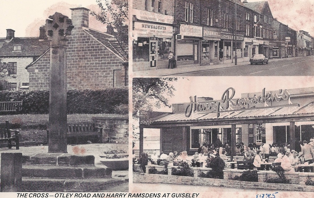
B459 – Multi-View Postcard, 1973.
Multi-View Postcard – 1973
On the left is Guiseley Cross sited in its present position with the Stocks and War Memorial. (August 2012)
A Frank Parkinson bungalow is in the background.
Upper right is a view of Otley Road. The shop on the left is F. Rhodes and Son newsagents, then Haigh’s Confectioners, Cohen’s Pharmacy (now at Broad Ing Pharmacy 26 Otley Road which was formerly Ushers Chemist) and John Dibb, grocers. (August 2012)
Bottom right, Harry Ramsden’s at White Cross. The tables are full outside and people are queuing to go in.
It is now the Wetherby Whaler. (August 2012).
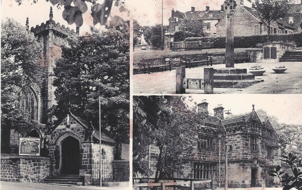
B458 – Multi-View Postcard, 1985.
Multi-View Postcard – 1985
St. Oswald’s Church is on the left, the Cross and Stocks upper right and the Rectory lower right.
“Card supplied by F Rhodes and Son, Newsagents, Guiseley”, this newsagent’s shop was on Otley Road.
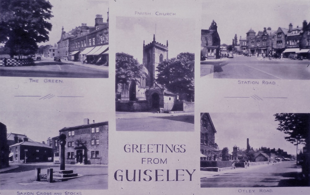
I319 – Multi-View Postcard, Undated.
Multi-View Postcard – Undated
A view of The Green is in the top left corner, in the centre is St. Oswald’s Church.
The top right corner has an image of Oxford Road (labelled as Station Road), in the bottom left corner is Towngate with Otley Road looking towards Oxford Road in the bottom right corner.
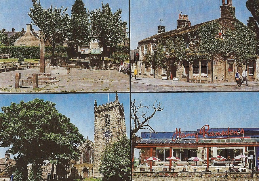
F961 – Multi-View Postcard, 1994.
Multi-View Postcard – 1994
Views of Towngate with the Garden of Remembrance, the Station Hotel, St. Oswald’s Church and Harry Ramsden’s restaurant at White Cross.
Donated by Lynne Moxon.
Consolidated by Linda Plonka. 28 February 2022.
Last updated: 02 March 2022.