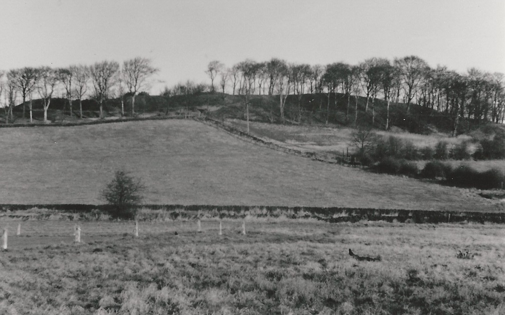
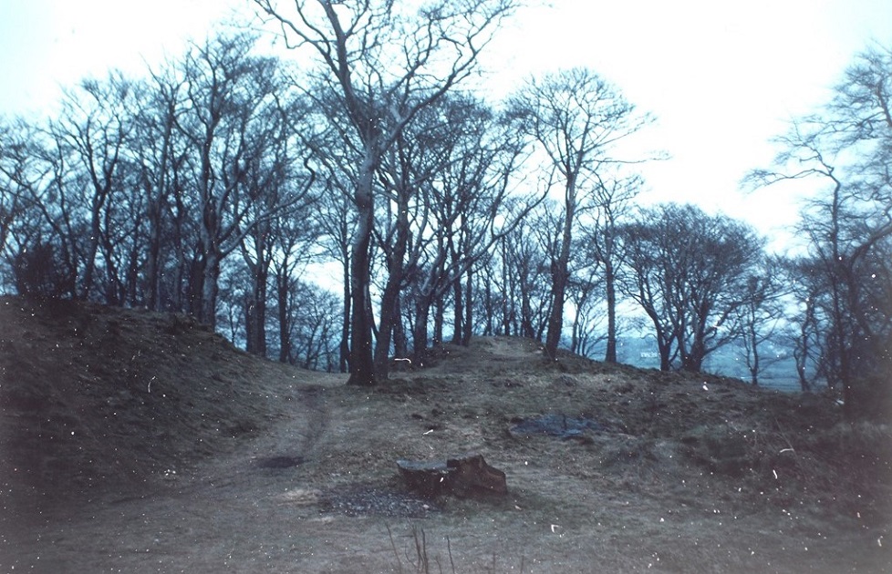
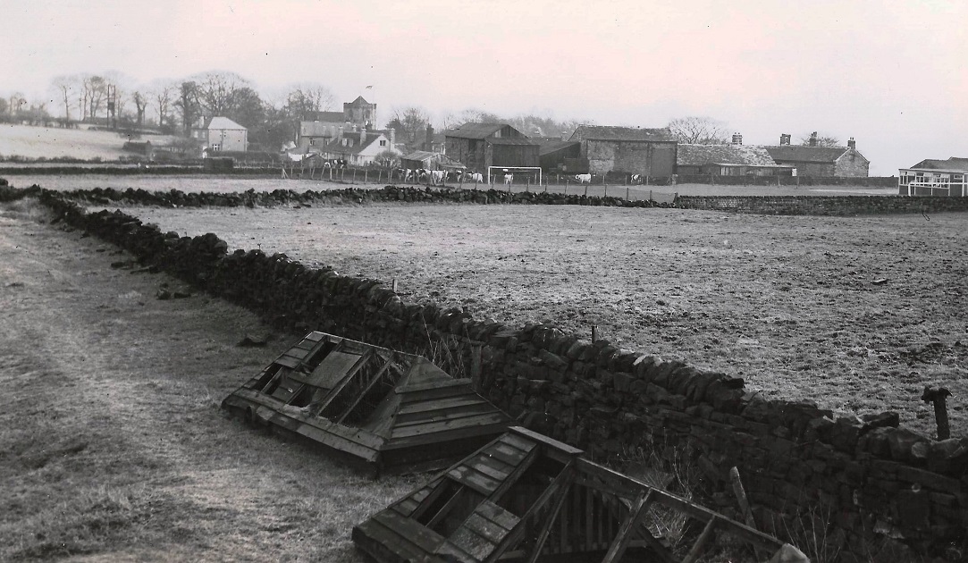
X182 – Billing Wood, 1985.
| Title | Billing Wood |
| Date | 1985 |
| Location | Rawdon |
| Photo ID | X182 |
| Comment | Rawdon Billing is an Aireborough landmark and a wooded hill surrounded by fields which lies between Rawdon, Yeadon and Horsforth. |
Billing Wood reaches a height of 231 meters (758 feet) and amidst the summit evidence of old c1800s quarry workings can be seen to this day. It is now owned by the Rawdon Trust, land agents for the Emmott family from Lancashire.
The Billing is a popular place for local walkers and plane spotters as it overlooks the Leeds & Bradford Airport.
The name ‘Billing’ is derived from ‘bill’ meaning highest point and ‘ing’ meaning field or meadow.
From this view of the Billing, one field over to the right, can be found a trigonometric point. From here, it provides superb views across the middle Aire Valley towards Emley Moor communications mast, and towards the Wharfe Valley and Vale of York.
The photograph above was taken around 1985.
Just below the tree line of the Billing, running parallel to the stone wall and to the right of the central footpath leading to the summit, once stood a small holding dating from the 1800s. In the early 1950s, the occupants had left and it was taken over by Billy Barrett who lived next to Grange Farm on Town Street. He used to keep pigs and chickens there and subsequently it fell into disrepair and was demolished in the 1980s.
During the mid 1930s, a very modern looking house was built on top of the Billing affording splendid views over the valleys below. It was positioned in the gap between the trees centrally, and directly above at the top of the footpath leading to the summit. Legend has it that because no planning permission had been obtained, it was demolished soon after completion. Remains of the foundations are still visible today. (July 2020)
The fields surrounding the Billing were once farmed by two dairy farmers. Intake Lane Farm at the foot of the Billing was farmed by Wilf Rushworth and the other Grange Farm to the right of the now St. Peter’s (C of E) Primary School, by Clara Louisa Braithwaite.
Intake Farm was located directly to the right out view in this photograph and was demolished in the 1970s and sheltered housing was built on the site by Leeds City Council. Grange Farm too was demolished and a car park for St. Peter’s School was constructed on the site.
To the left of this image can be seen concrete posts marking the boundary of the Rawdon football field.
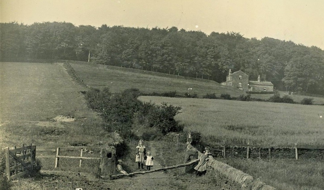
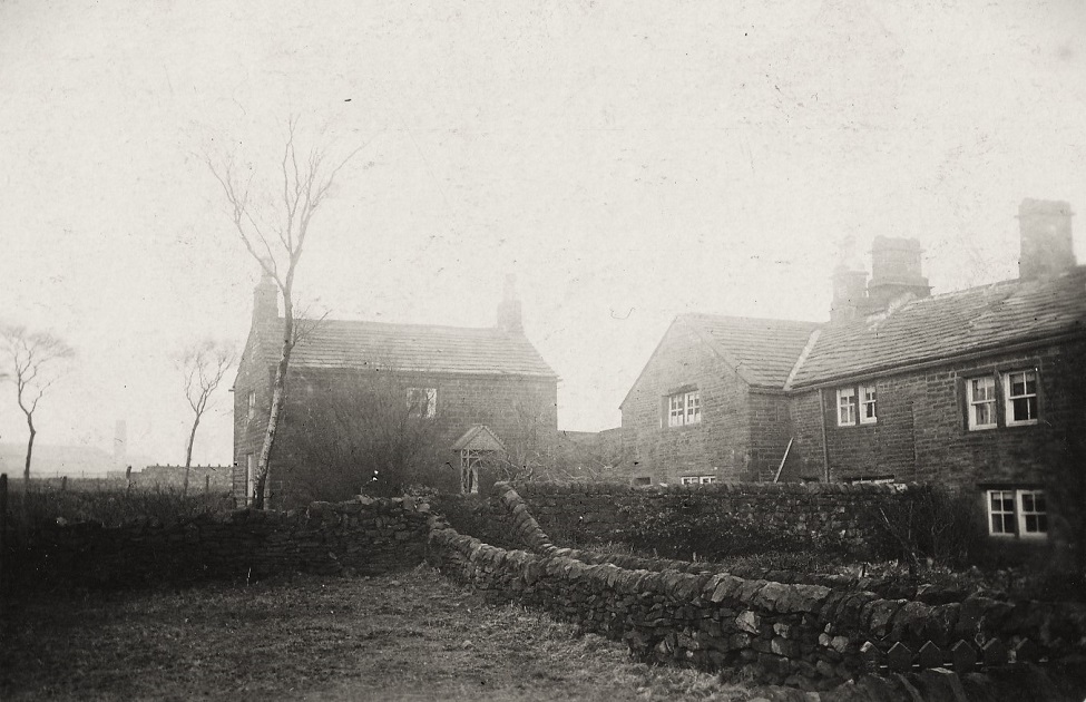
S115 – Billing Wood, c1890s.
Billing Wood – c1890s
A photograph showing the small holding as described above. It is believed that tenants were a family named Wood and that Mr Walter Wood was a breeder of fox terriers.
It is probable that some of the children in the foreground lived in the small holding. The track leading up to the Billing and the small holding is directly behind the children. It has become quite overgrown with shrubbery, however, underneath all this can be found sandstone slabs on which the carts from the quarry used to travel on to stop getting bogged down in inclement weather.
Note also the abundance of trees on the Billing at this time. Also note that whitish area just behind and to the left of the children, this was early excavation of a possible coal deposit. It was still visible in the 1970s.
I quote now from Roland Brindley, who like me lived locally to the Billing:
“I think a family called Wood lived there in the immediate post WW2 years, before that I cannot say, and sadly the Rawdon people I knew who may have provided answers are no longer with us.
After they moved away the cottage and outbuildings was in use by Billy Barrett, a cantankerous partially lame old bachelor who lived at number 30 Town Street, with his not quite so cantankerous brother Arthur, who was a plasters labourer among other activities.
Billy bred pigs up there on the Billing, where he disposed of his produce I have no idea but it’s certain that his slaughtering arrangements would not have satisfied the public health regulations even in the 1950s.
He drank in the Old Ball (both old and new versions) (Ed: Horsforth) and sight of him waiting for the Ledgard bus at the top of Carr Lane was frequent. I never saw him in the Emmott Arms although it was his nearest pub. His brother Arthur did not drink beer to the best of my knowledge.
Although very strange men they were part of Rawdon and I never heard a single word bad about either. Arthur died long before Billy, and I shudder to think of the state their house must have been in towards the end of their lives. Billy was friendly enough during the many years I knew him, although his language was not for the best of circles.”
Billy Barrett was a character. His normal daily attire were wellington boots with the tops turned down. Blue overalls and a blue denim type jacket , always open and flapping in the wind and last but not least, a black fedora hat. He also had chickens on the Billing and you could see him daily walking up there with a bucket of swill and returning with a bucket of eggs. Billy never lived there as there was no electricity and his pigs and chickens took up most of the ground floor area. I always used to see the light of a hurricane lamp during the winter months. A very lovely man as I knew him. (Ed. Jack Brayshaw. Feb 2021)
To the immediate right of this image and just out of view is Rawdon Dam also referred as Billing Dam.
Photograph donated by Peter Lambert enhanced by Jack Brayshaw.
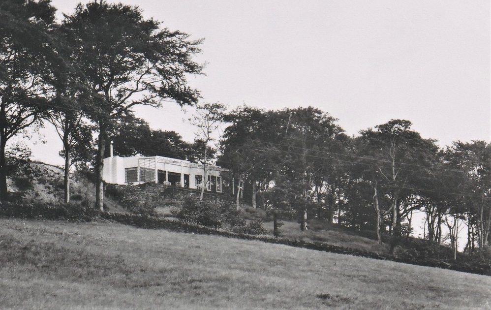
U933 – Billing Wood, c1936.
Billing Wood – c1936
During the mid 1930s, a Mr Dawson applied for and was granted temporary planning permission to build a house on the very top and front of the Billing.
It was completed and was a very modern looking building for the times affording commanding views of the valleys below. However, shortly after completion the sanitary provisions were not up to regulations and the whole building was subsequently demolished.
It you look carefully today, you can still find quarry tiles and asphalt belonging to the building amongst the grass and shrubs. (Ed. Jack Brayshaw. 2014)
Donated by Jack Brayshaw.
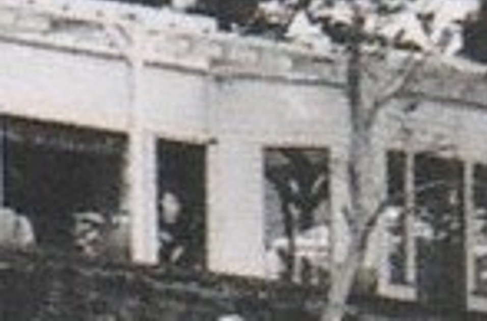
U934 – Enlargement of U933 above.
Billing Wood – c1936
For many years I have had the postcard photograph of the house on the Billing given to me by my parents who lived at the foot of the Billing on Billingwood Drive, in fact where I was born! It is only just recently that I have re visited this photograph and with technology now available, I made the enlargement opposite.
I was astounded to find a person standing in the second window from the left! Was this Mr or Mrs Dawson? perhaps we will never know, and did he/she see the photographer down in the fields below taking this picture, again we will never know. (Ed: Jack Brayshaw. Feb 2021)
Donated by Jack Brayshaw.
JH016 – Billing Wood, 1950s.
Billing Wood – 1950s
During the 1800s, the Billing was actively quarried for stone for use in structures locally and also for the foundations of 48 Albion Street, Leeds. The former bank now houses a Starbucks.
As a child in the 1950s, we used to play on what we called the ‘Sand Mountain’ a large man made hill of sand approximately 20 feet high the result of the quarrying and piled up with unwanted large boulders of sandstone on one side. From the summit it was approximately 40 feet to the base of the quarry. The boulders were so placed that youngsters could slip easily into the gaps to play. During the 1970s/80s, the sand mountain was levelled as a precaution of the boulders slipping back into the quarry and injuring or causing death to some person.
From behind where the sand mountain had been, the view takes you over Markam Avenue, Benton Park School and beyond. A foot path used to run from this point along the fields behind Markham Avenue estate to the Samuel Ledgard’s Moorfield Depot, exiting near to where the Peacock Public House used to be.
There is a gate to the side of the now levelled sand mountain which takes you along the edge of a farm field and to a minor excavation hole. Along this footpath a steep decline is to the left and covered with bilberries at the time of year. Many a summers day was spent here watching Tiger-Moth aeroplanes performing aerobatics from Yeadon Aerodrome.
(Ed. Jack Brayshaw)
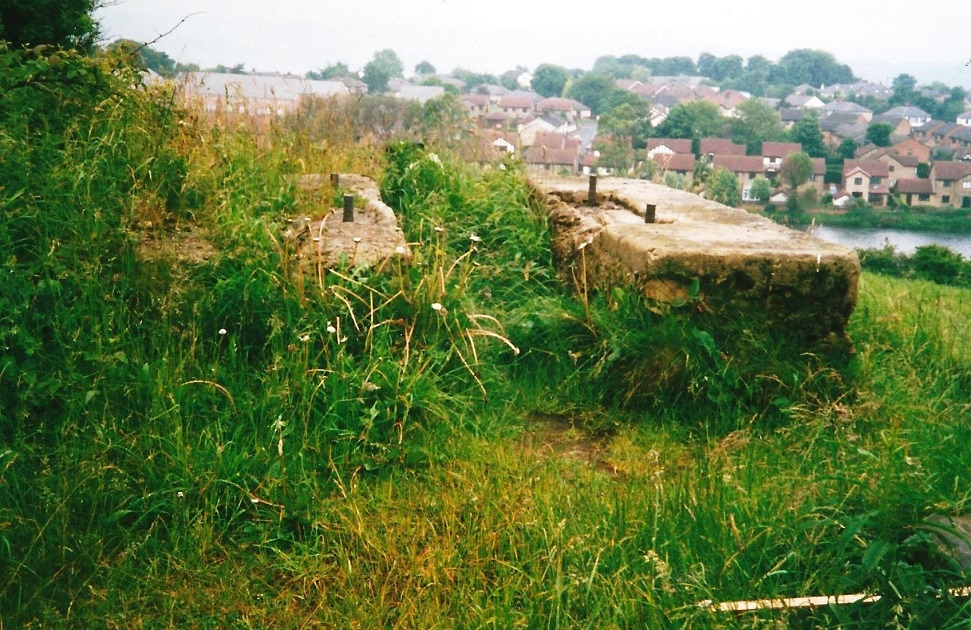
X95 – Billing Wood, Concrete Blocks.
Billing Wood – Concrete Blocks
There has been much discussion over the years as to what these concrete blocks are. Some say they are the remnants of foundations for WW2 Anti-aircraft gun emplacement there to protect the AVRO factory next to the now Leeds and Bradford Airport; even foundations for WW2 search lights and that they are ballast blocks used by the Quarriers back in the 1800s. Even local historians have intimated that they are of WW2 origin in their guides and booklets on the Billing.
I have searched military records of the time and cannot find any reference to any form of anti-aircraft gun emplacements/search light emplacements ever being installed on the Billing during WW2.
I have though examined the concrete blocks over the years and in fact having played on them as a child. Now in my later years, I can can give an informative conclusion having worked with concrete and of having a military back ground. In my opinion, they are the remnants of ballast from the cranes used at the Billing quarry in the 1800s. They do not conform to anti-aircraft gun foundations or search light foundations, being laid on the surface and not as you would expect, to be part of a structure which is below ground for stability.
There is also no evidence of support structures to house the ammunition or billets for the gunners as well as communications. In fact the casual viewer even today, is able to see the poor quality of the concrete composition used in their construction.
To support my theory I draw your attention to the Carlton Anti-Aircraft emplacement via this link here – Carlton Anti-Aircraft, where you will see what an anti-aircraft gun emplacement looks like.
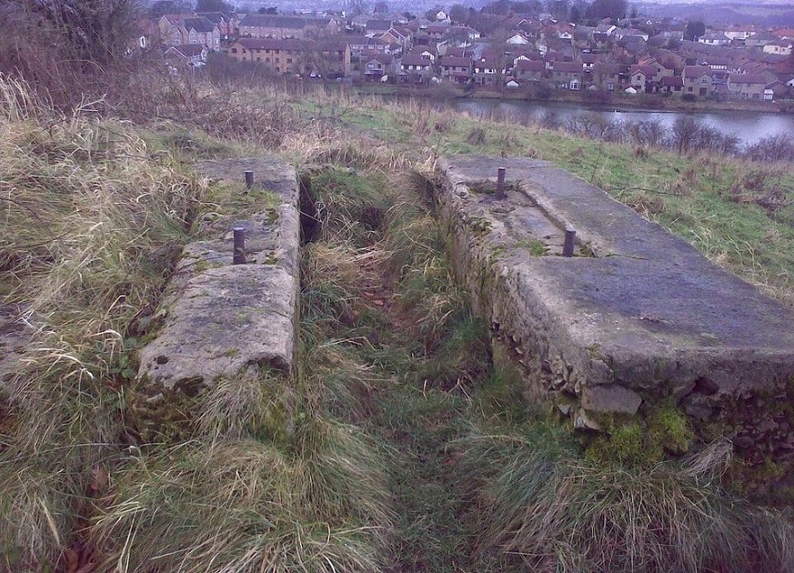
U942 – Billing Wood, Concrete Blocks.
Another photograph of the concrete ballast blocks – note also that they do not conform to the principles of a base structure for such large anti-aircraft guns. The metal bolts would have been longer and have been cut down probably when the quarry shut down.
In the 1950s, to the right of these blocks and adjacent to a track a small concrete structure had been built, its purpose unknown but possibly used as a store. This too over the years has been demolished.
To the left of the blocks is located possibly the first quarry. Again the track as previously mentioned used to pass by this quarry and just down off the track and along the side of the workings was a flat concreted area, the base presumably supported stables for the horses required to transport the stone. (Ed. Jack Brayshaw)
Donated by Jack Brayshaw.
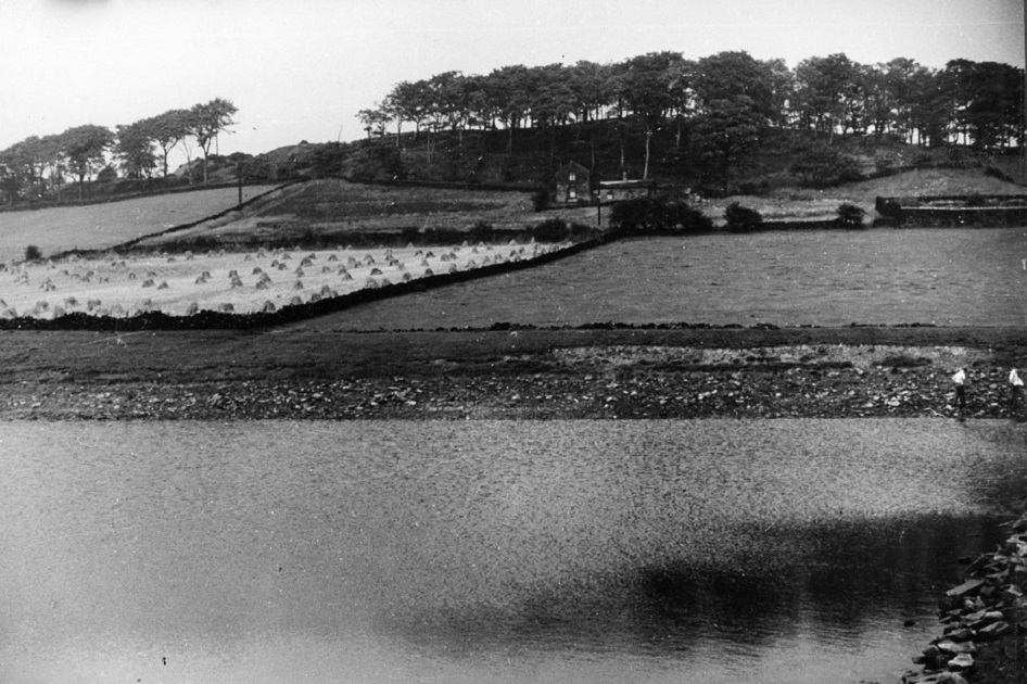
K080 – Billing Wood/Billing Dam.
Billing Wood – 1960s
The Billing is a source of fresh water filtered by the sandstone. This was capitalised in the 1800s, and a holding tank/well was constructed below and to the right of the small holding as you look at it in the 1800s. The holding tank was circular in construction and as I recall, titled. The holding tank was surrounded by a high stone wall on all sides and supplied water to a trough at the side for cattle, and also for Intake Lane Farm and many of the local houses for many years.
You can just see the wall top right side adjacent the hedgerow and footpath.
Although the holding tank is now filled in and the surrounding wall in disrepair, the trough for cattle still remains filled with water. (Ed. Jack Brayshaw. Aug 2020)
To give you some idea of what the holding tank looked like the Moor Lane Reservoir, Guiseley, looked very much the same as the Billing holding tank – please Click Here.
In the foreground is Billing Dam and as you can see here it was partially drained, the depth at this end is approximately 15 feet deep. The depth can further be gauged by the outlet valve located just out view to the right of the image down the dam embankment surrounded by large sandstone blocks. The field directly behind the dam was abundant with mushrooms during late August and early September and provided a lovely Sunday breakfast with bacon and eggs. (Ed. Jack Brayshaw.)
Photograph donated by Val Ryan.
D349 – Billing, Intake Farm & Grange Farm, 1970s.
The Billing, Intake Farm & Grange Farm – 1960s
In the foreground of this image can be seen two old hen huts utilised by Intake Farm. They were usually located at the entrance to the dam and many a day they were upturned to expel rats which housed beneath them. A variety of weaponry was used during such events. To the immediate left and out of view is Billing Dam.
The field immediately to the right belonged to Intake Lane Farm and backed onto the houses on Billingwood Drive.
At the bottom right you can just see an outside classroom of St. Peter’s (C of E) Primary School, which places this photograph to have been taken during the late 1960s. To the center are the school football and playing field.
In the far distance, cattle and farm buildings of Grange Farm are visible, long since demolished and now form the Schools Car park. And of course you can just make out the clock tower of St. Peter’s Church flying a flag on the day this image was taken.
V514 – Billing & Intake Farm, Undated.
The Billing & Intake Farm – Undated
An early photo of Intake Farm, seemingly shrouded in low cloud.
Donated by Maureen Naylor.
Editor’s Note: The low stone wall leading from the right to the middle of the image is a narrow Ginel which bent round to the right and past the gable end of the house on the right to the residents outside toilets. It then joined an unmetalled track to the cricket and football fields. The house in the center is Intake Cottage and was demolished in the mid to late 1950s. To the right of the Ginel are the small gardens of Intake Farm which is shown here on the immediate right, then two rented properties. Another rented property is out of view but was the first in that row of four dwellings. The field to the left of the Ginel during the 1950s contained open fronted tractor and farm machinery sheds and chickens. At the bottom right of the image was a gate leading onto Intake Lane and the rear garden of 12 Billingwood Drive. The area to the left of Intake Cottage was used as allotments. Jack Brayshaw. 07 Nov 22.
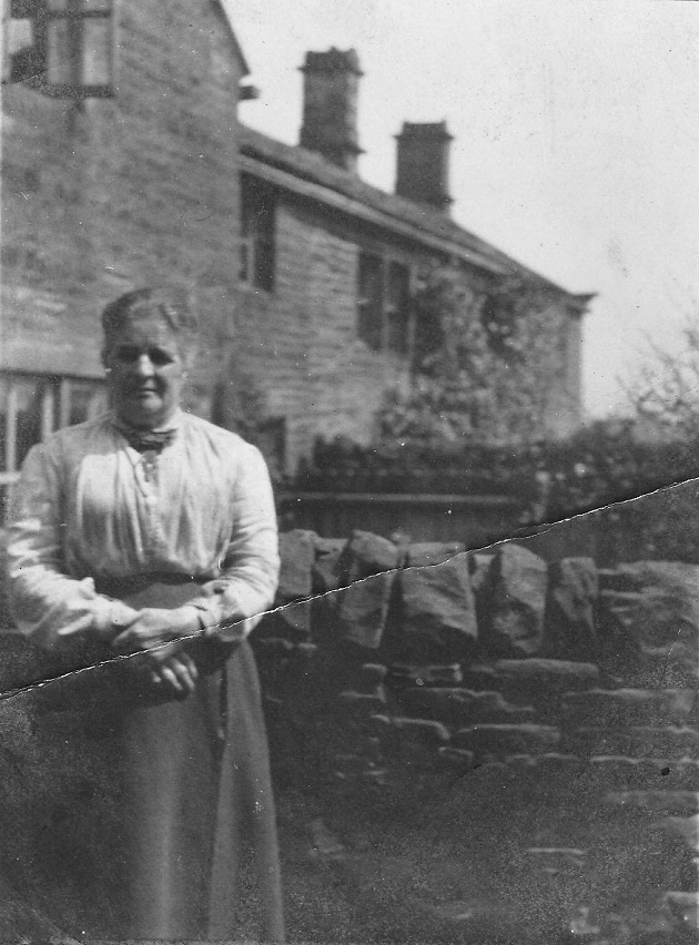
W517 – Billing, Intake Cottage & Intake Farm, 1905.
The Billing, Intake Cottage & Intake Farm – 1905
The following two photographs are of the donors Great Grandma Sarah Elizabeth Richardson.
She was born in 1856 and died in 1943. Her parents were William and Maria Richardson. She married 3 times.
First to Sam Smith in 1880 and had 3 children. Sam died in 1887.
She then married James Sutcliffe in 1894 and had 2 children.
James died in 1912 and she later married John Lee.
She spent most of her life living at Intake Cottages although her daughter Eva Sutcliffe was born at Henley View. In 1935 she was living with her daughter Jane Ellen Beck and granddaughter Agnes May. Agnes May married Francis Gill from Intake Farm in 1937. In 1939 she was living on her own at 8 Larkfield Mount and died in 1943 at her daughter Eva’s house at 1 Egerton Terrace, Rawdon.
Donated by Maureen Naylor.
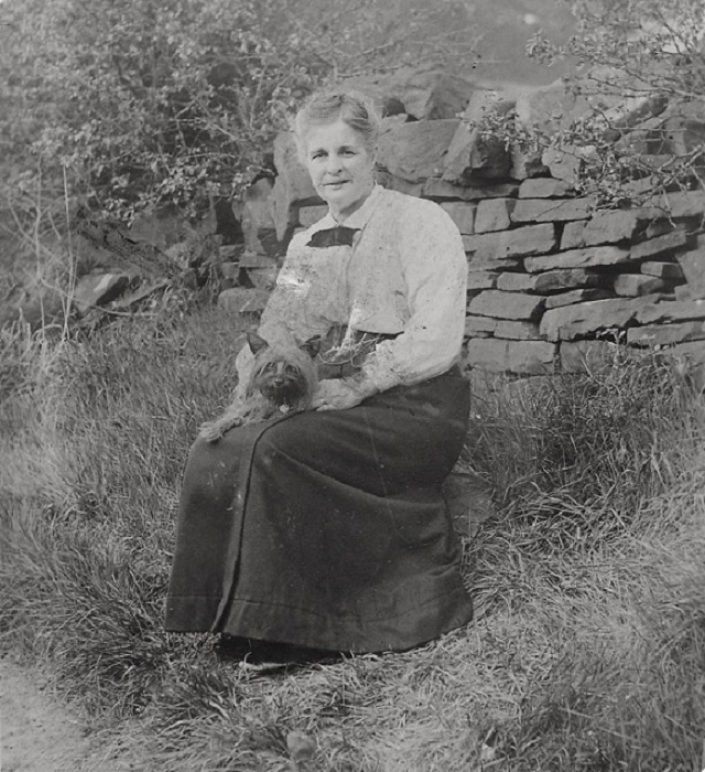
V518 – Billing & Intake Cottage & Intake Farm, 1905.
The Billing & Intake Cottage & Intake Farm – 1905
As above.
Donated by Maureen Naylor.
As well as a lovely lady, a cute Yorkshire Terrier as well. Ed.
W515 – Billing, Intake Cottage & Intake Farm, 1922.
The Billing, Intake Cottage & Intake Farm – 1922
The writing on the back of the picture of the young man says G.W. Smith.
Intake Cottage Rawdon 1922.
Donated by Maureen Naylor.
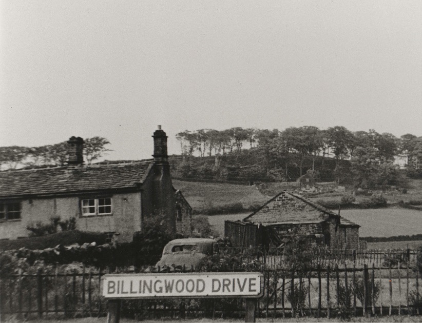
X883 – Billingwood Drive, c1958.
Billingwood Drive – c1958
An image taken by my late father Jack Brayshaw (Senior) c1958, taken from outside our house garden at 12 Billingwood Drive, Rawdon. Below the sign out of view, was a young growing Hawthorne hedge running around the perimeter of the garden, the grass of the lawn just visible below the thicket fence running left to right. The house on the left was part of Wilf Rushworth’s, Intake Farm, lived in at this time by Mr & Mrs Reynolds and their sons Mark and Duncan. You can just see the edge of the farm mistall level with the gable end. In front a wooden shed for use by the first cottage, after that was the snooker room followed by the farm tractor workshop/garage.
In the distance beyond is Billing Wood and just off centre a small holding built in the 1800s and later used by a local man Billy Barrett for raising pigs and chickens.
The dilapidated car in the foreground was a Riley 2.2 which my father was dismantling for spares for his Riley 2.2. This view now longer exists, as the farm and small holding were demolished in the 1970s the former to make way for sheltered accommodation built and run by Leeds City Council.
In this view of the garden, now stands a new property No: 12a Billingwood Drive, built in 2021/22. No: 12 is still there next door just out of sight on the right.
Donated by Jack Brayshaw.
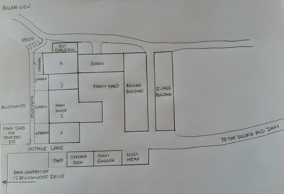
U943 – Billing & Intake Farm, 1960s.
The Billing & Intake Farm – 1960s
Unfortunately no images are currently available showing the whole of Intake Farm, however, from my hand drawn sketch I have displayed it how it looked in the 1960s. If you relate this to the present sheltered housing which was built on the site it is quite easy to see where these buildings once stood.
Donated by Jack Brayshaw.
You will note that on my sketch Intake Cottage is not shown. This is because I thought it was located further to the left. JB. 07 Nov 22.
Previous Comments:
teleg
I spent a lot of time up Billing with my children and Grandchildren and also walking and sledging in winter, and my wife’s Parents ashes are scattered on Billing My father – in – Law also wrote a poem about the Billing when he was in Australia before the first world war and feeling homesick.
21 May 2013.
teleg
The sun may shine on Billing hill
As it has often shone
The sun will rise on Billing Hill
After I have gone
The dawn will break on Billing Hill
And some there’ll be to see
But there will be a world between
Old Billing Hill and me
06 October 2013.
Stephanie
How nice to read a poem about Billing. Love the two girls in smocks at the bottom of the hedged path. We used to blackberry there in the early 50’s when we had the shop in Canada Road. Dad used to ice-skate on the frozen ‘dam’, as local’s called it. My fondest memory was of harvest time when some of us children would sneak into the field to hide and seek amongst the hay stooks.
Stephanie May.
10 January 2018.
Re X182
Graham Branston
A football pitch can just be seen on the fourth photograph. The Rawdon team, like many others was originally made up of members of the local church, St. Peter’s. All members had to attend Bible classes! The field where they played was known as ‘Nowhere’, no doubt it was used courtesy of the Emmott family. The players used the old schoolhouse, later known as the Institute for changing and basic showering. The local team now plays on a pitch next to Rawdon Cricket Club at the foot of The Billing.
09 February 2018.
Re K080
hannah1
The bottom picture shows the isolated farm at the bottom of billing, do not know what it was called but we have it on previous pictures. We used to play in it during the 2nd World War and it was empty then. The approach to it was alongside the Emmott’s Arms, r. h. side and up a cart track, many hours spent blackberrying. The lake at the front we called it the Lido and used to paddle in it, the brave ones used to swim. The gap between the trees on the top of Billing, there used to be a house, very modern and mostly glass but it was built without planning permission and was eventually pulled down after the war. You can just see two boys on the r.h.s looking into the water
25 February 2014.
valryan85a
So glad you remember it hannah1 I have very fond memories of going up the lane to the old farm and Black Berrying. There was a very deep well to the right on Billing with a blackened wall all around it and a large stone cattle trough on one corner and it used to scare me to go past it!
21 June 2014.
Re K080
adminCWAB1
I lived not far from this farm in 1966, I was a pupil at St. Peter’s and I can recall a family called Drake’s who lived in the farm house and they had a small herd of Friesian cows. I can remember watching them walk up the fields to the east side of the Billing and graze and in the afternoon they would come back by the side of the Dam to be milked. I can recall one assembly when it was announced that they were leaving and the father was going to go to Pontefract. The building then was demolished and became the car park it is today.
16 January 2021.
Page 1 of 2 More >>
Consolidated by Jack Brayshaw. 16 February 2021.
Last updated: 06 June 2023 – Photo ID: X883. 07 November 2022 – Photo ID: V514, V515, V517 & V518. 23 September 2022 – All Images updated.