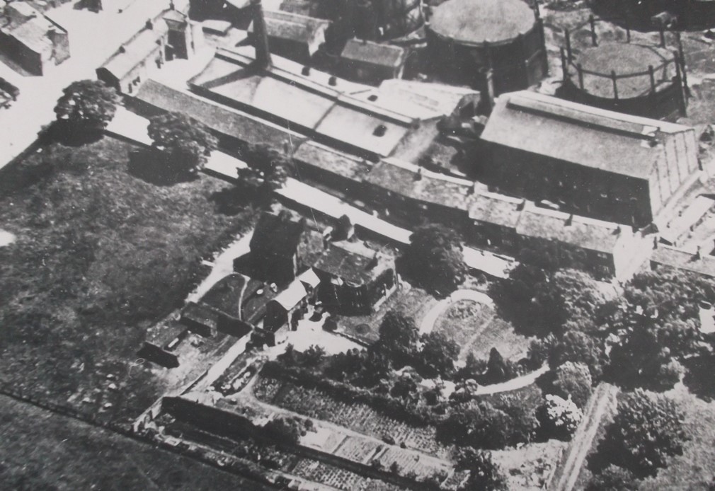
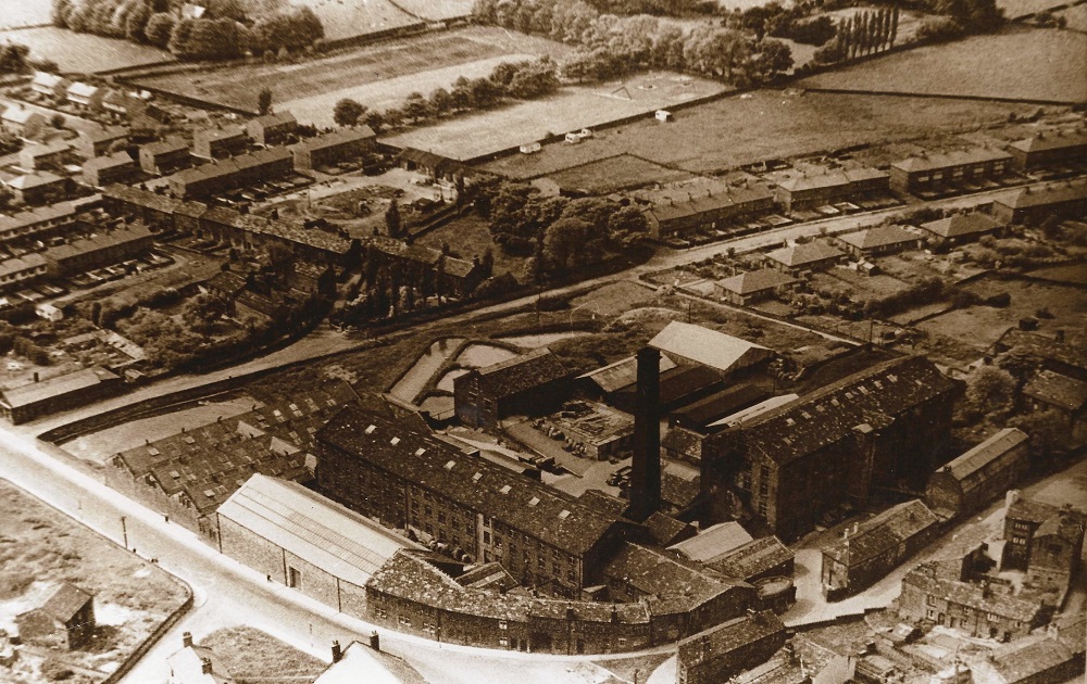
| Title | Aerial Views |
| Date | 1935 |
| Location | Yeadon |
| Photo ID | I137 |
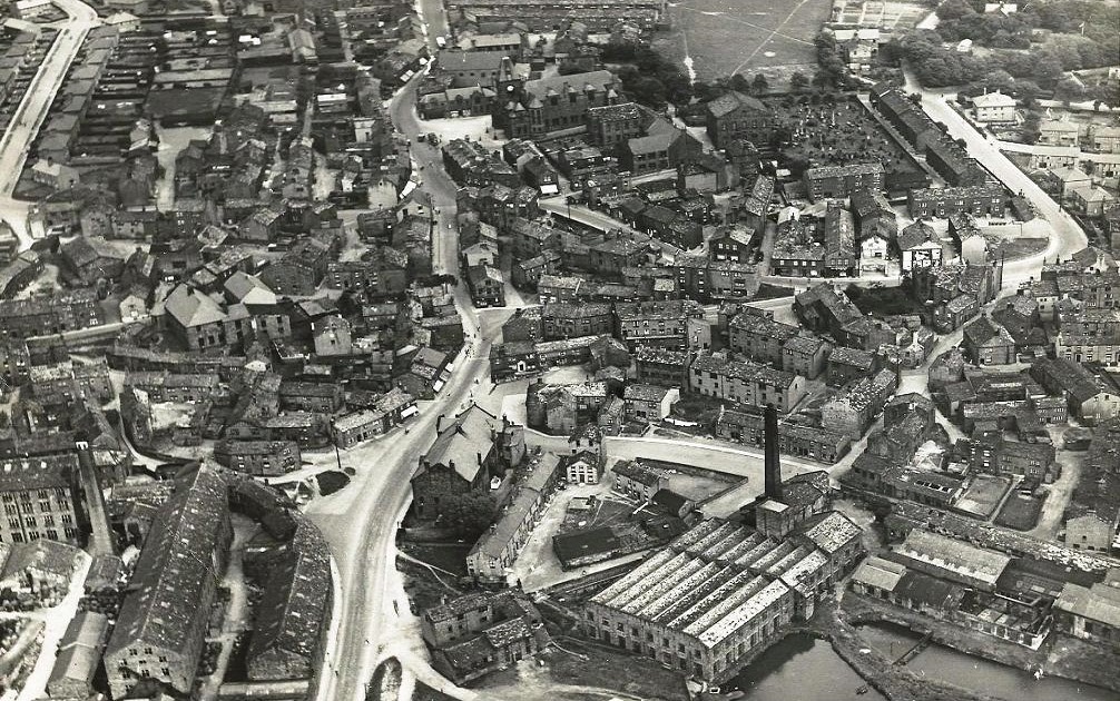
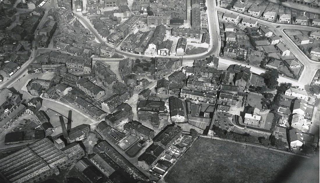
| Comment | Running left of centre from top to bottom is High Street then Town Street (Steep) and Kirk Lane. The Town Hall is located in the upper centre, the Wesleyan Methodist Chapel and Burial Ground lie to the right of the Town Hall with Harper Lane in the upper right corner. All the vanished yards and streets of old Yeadon are seen in this photo including those in the Well Lane / Abbey Lane and Chapel Lane areas. In the lower section on the left is James Ive’s Manor Mill to the right are the Temperance Hall and the Old Dog Mill. |
I139 – Aerial Views, 1935.
Aerial Views – 1935
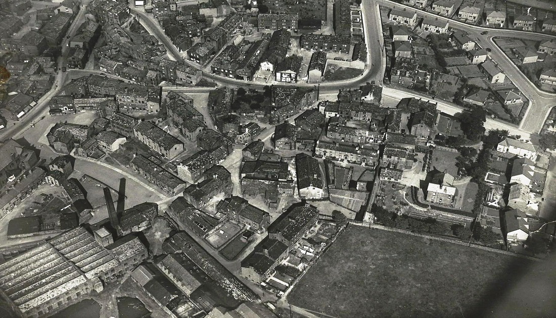
At a slight diagonal across the top left corner is the High Street then Town Street (Steep).
Ivegate is the loop shape joining the High Street in the top left corner, turning into Harper Lane towards the right.
The Temperance Hall is just on the left edge above the Old Dog Mill, top centre is the Wesleyan Methodist Chapel and Burial Ground with Harper Lane to the right.
South View School is in the top right corner, below the school are the newer houses on Brooklands Crescent and Drive with Henshaw Lane coming in from the mid right edge.
K242 – Aerial Views, 1935.
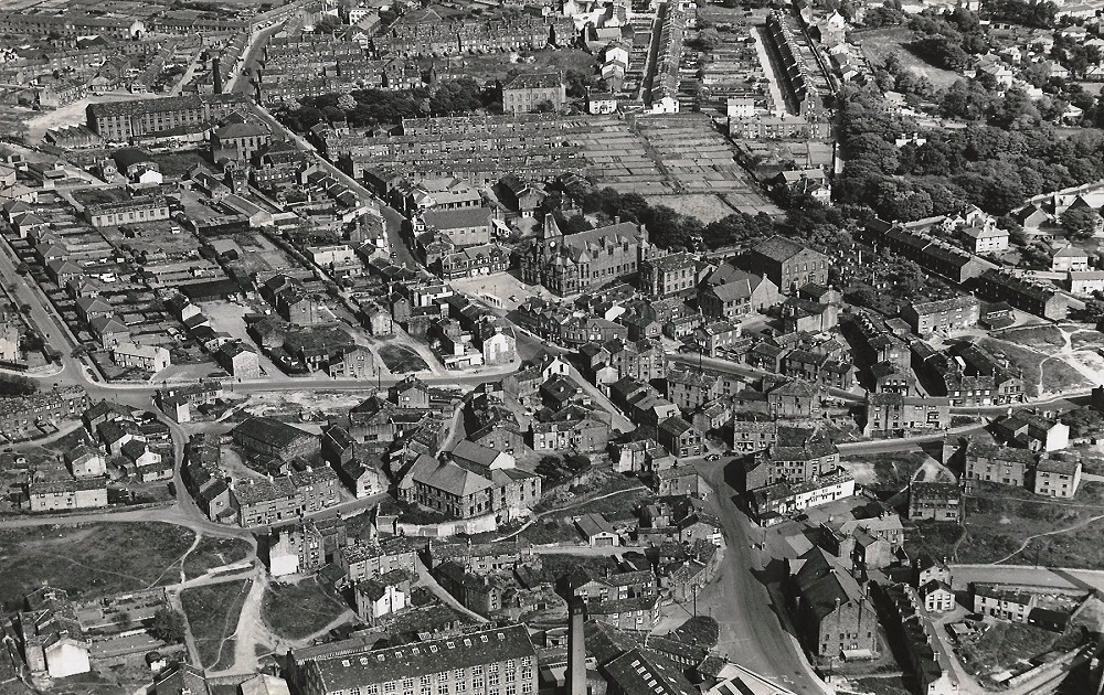
Aerial Views – 1935
June 27th 1935: Yeadon Town Hall is in the centre of the view, the High Street runs from the top down to join the Steep (Town Street) at the junction with Ivegate which is 3/4 way down on the right.
Amongst all the old streets and yards now long gone landmarks can be picked out, Albert Mill is in the top left corner, Yeadon Picture House is just above the Town Hall. The Primitive Methodist Chapel is to the right of the Town Hall, the Wesleyan Methodist Chapel is in the middle on the right edge.
FBA311 – Aerial Views, c1935.
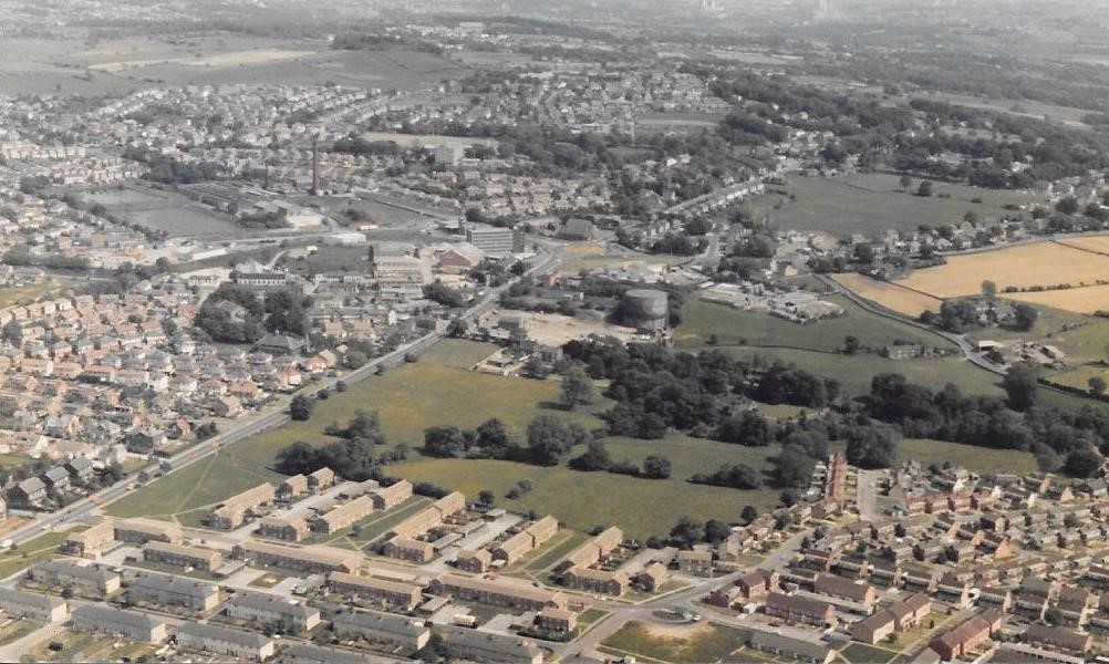
Aerial Views – c1935
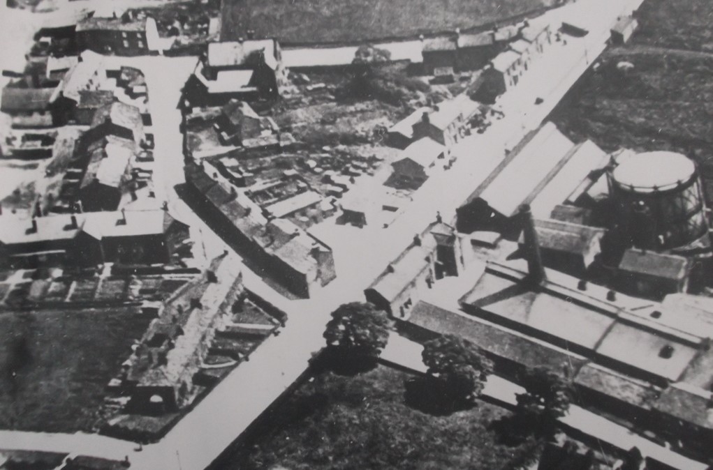
This view is of the Gill Lane area.
The Yeadon and Guiseley Gasworks dominates the middle of the scene with New Road (A65) running left to right below the gasworks.
Apperley Lane runs diagonally across the top left corner, in the bottom left corner is Sizers Hill.
The road to the right of Sizers Hill is Henshaw Lane, the old Church of England School is at the point of the triangle where Henshaw Lane and Gill Lane meet.
In the bottom right corner are Dinsdale’s Buildings, the Woolpack Inn is at the corner with New Road and Gill Lane (not clearly seen).
Crossing New Road, Gill Lane continues past the gasworks, Low Hall is on the right.
Donated by Jean Dean.
I153 – Aerial Views, c1935.
Aerial Views – c1935
The road running from the top left corner to the mid left side begins as the High Street then becomes Town Street (the Steep).
The loop of road in the upper mid section is Ivegate coming in from the High Street on the left then turning a straight line up to the top edge as Harper Lane. South View School is in the upper right corner, below is Brooklands Crescent/Drive then the next road down is Henshaw Lane.
In the lower half of the view are the old streets in the Well Hill, Abbey Lane and Howarth Lane areas.
In the bottom left corner is the Old Dog Mill.
From the collection of James Farrar, donated by his son David.
C250 – Aerial Views, Post 1935.
Aerial Views – Post 1935
The New Road cuts across the centre of the view, at the top line is Sizers Hill off Henshaw Lane.
Gill Lane begins top left and runs right across the picture to bottom right.
The church school built by donation from Mr. Barwick is on the corner of Henshaw Lane and the top of Gill Lane to the right.
Dinsdale Buildings run from right to left mid centre. Most of the cottages on this section have gone except for three shops and the Woolpack Inn opposite.
The little row of cottages mid left are on New Road Side.
Across the New Road going down Gill Lane we pass the old garages and the cottages belonging to the Gas Works.
C251 – Aerial Views, Post 1935.
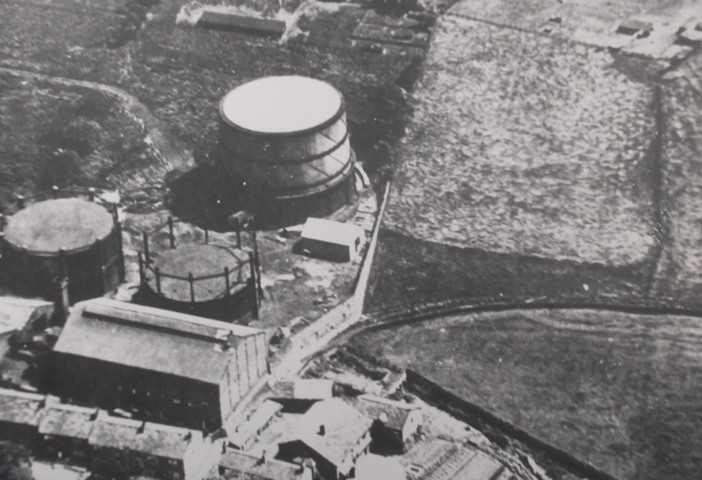
Aerial Views – Post 1935
A view of the gas works with cottages at the bottom, an old lane, Goit Lane arc’s off to the right, it leads to Warm Lane.
C252 – Aerial Views, Post 1935.
Aerial Views – Post 1935
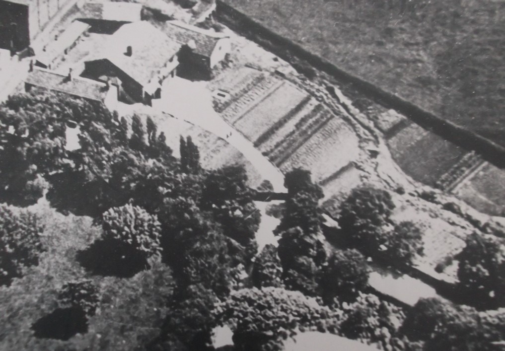
A view of two cottages and a barn belonging to Low Hall, the barn was used to house the coaches.
The gardens were used for produce, the beck runs top middle to the right and under Gill Lane, it flows from the Dam at the top of Yeadon.
C253 – Aerial Views, Post 1935.
Aerial Views – Post 1935
A bigger view of cottages on Gill Lane, with a farmhouse where they kept pigs ( now No’s 24 and 26 ) middle left, next to this is a house that used to belong to Julia Dinsdale, but now tenanted (August 2014).
The gardens at the bottom used to be allotments.
C499 – Aerial Views, Undated.
Aerial Views – Undated
On the left is Kirk Lane, the Manor Mill complex dominates the middle of the scene, it was the business of James Ives & Sons until it was demolished in 1980. Walker’s Row leading to Swincar Avenue runs horizontally across the image.
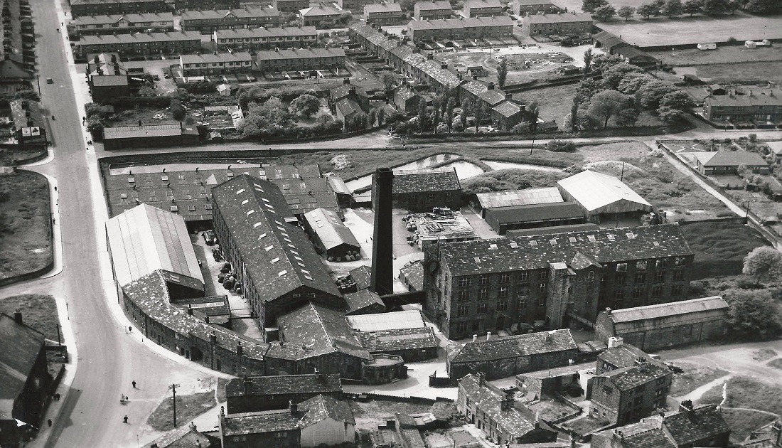
T67 – Aerial Views, 1950s.
Aerial Views – 1950s
Moorefield Mill Arial View – Harrogate runs across the top of the view from left to right, a short Stretch of Bayton Lane is seen to the right of centre, the High Street comes down to the right hand corner.
The Moorfield Mill complex occupies a site between Harrogate Road (Victoria Avenue) and the High Street. On the left behind the mill is Moorfield House, home of mill owner William Murgatroyd.
In the foreground a cricket match is in progress on the White Swan cricket pitch.
D179 – Aerial Views, 1951.
Aerial Views – 1951
An aerial view of Manor Mill which was owned by James Ives & Sons, this photo was taken before a new shed was built to the rear of the mill.
Kirk Lane is to the right with Sandy Way in the top right corner.
The Temperance Hall is the large building to the right of Kirk lane, behind the mill is Manor Road, the old housing at the corner with Kirk Lane has been replaced by an apartment complex (April 2014).
The large building in the top middle is the old Church Institute, now converted into apartments, Manor Mill was demolished in 1980.
A194 – Aerial Views, 1951.
Aerial Views – 1951
Leafield Mill was built by William Starkey, he wanted to power the mill using a perpetual motion device based on the Biblical story told in the book of Ezekiel, “A wheel within a wheel”.
He gave a lecture in Yeadon Wesleyan Chapel in July 1868, his ideas were dismissed by engineers but he persisted.
He built a 4 storey block with no floors but platforms, this was to access an enormous wheel which would have hollow “S” shaped spokes filled with iron balls which supposedly move when the wheel turned and the whole apparatus would continue to move perpetually and provide motive power.
He died in 1879 having failed to find a manufacturer to make the giant wheel.
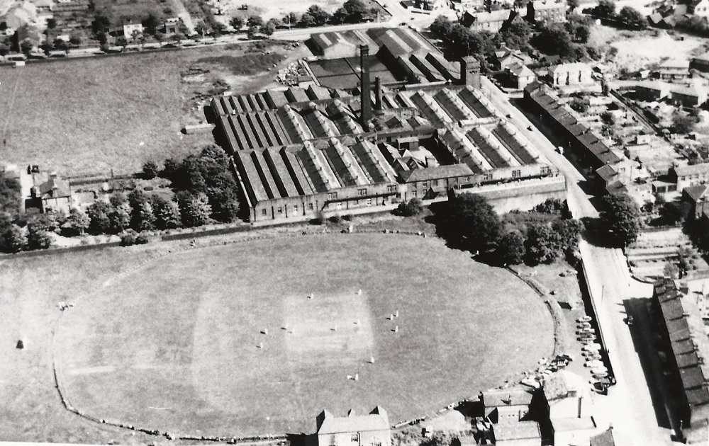
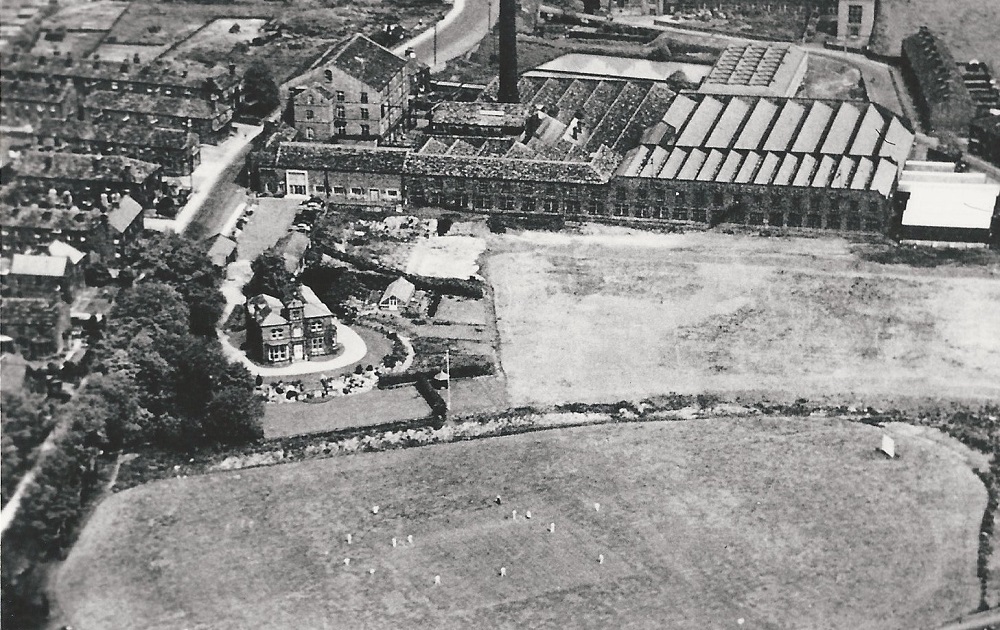
B064 – Aerial Views, 1951.
Aerial Views – 1951
Leafield Mill was finished in 1884 and taken by James Ives.
Mr Starkey’s original 4 storey building is the portion of the mill facing onto Kirk Lane. Leafield House is a little south of the mill with the mill cricket pitch in the foreground. Whack House Lane just under the top edge then makes a turn south before going off at the right edge.
The mill was demolished in 1984, a housing estate is on the site.
B098 – Aerial Views, 1954.
Aerial Views – 1954
Yeadon High Street begins at the top between the left corner and the center.
It continues down to the Steep (Town Street) which in turn joins Kirk Lane to end at the bottom of the image with the Temperance Hall on the right.
Moving back towards the top of the High Street the large mill on the left is Albert Mill on Albert Square.
Just slightly below is the Lecture Hall at the corner with Marshall Street,
Yeadon Town Hall can be clearly seen on the right.
Going down again to the road junction, Silver Lane is to the left and Ivegate to the right, Ivegate and Sandy Way meet further to the right.
Sandy Way runs back towards the center and the bottom of the Steep.
Just past this junction the white building to the right is the Oddfellows public house (now closed), between here and the Temperance Hall is the Robin Hood Inn (now Tut and Shive).
Manor Mill is on the bottom edge in the center.
Just below the top edge in the center the large building is Queen Street Chapel, below that Starkey’s Fold.
To the right of the Town Hall is the Primitive Methodist Chapel with the Wesleyan Methodist Chapel behind it.
The burial ground still has the gravestones intact, the houses on the right of the burial ground face onto Harper Lane.
Rufford Avenue is immediately below the belt of trees.
On the left between Silver Lane and Manor Mill the large building is the Church Institute which is now apartments.
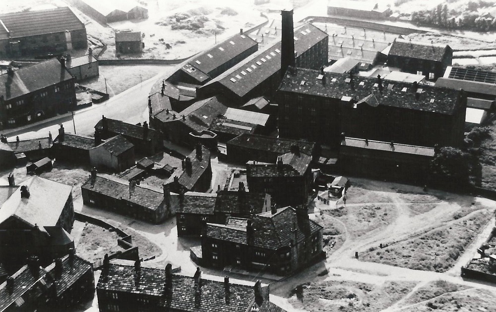
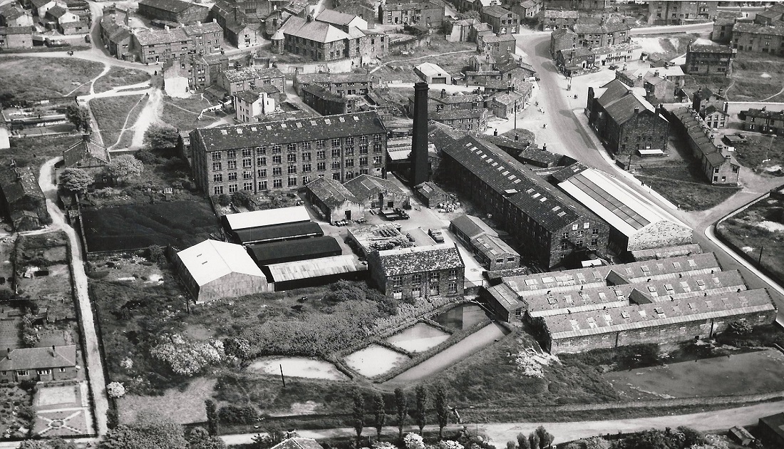
M077 – Aerial Views, 1955.
Aerial Views – 1955
The Manor Mill complex dominates this scene.
In the top left corner is part of the Old Dog Mill, Kirk Lane runs from the middle of the left edge past Manor Mill.
In the foreground is a cluster of small streets and yards now demolished, an apartment block is now on the site (December 2012).
Between these houses and Manor Mill is Manor Road, Haworth Lane runs parallel to Manor Road from just below Kirk Lane on the left edge and proceeds to the right between the houses.
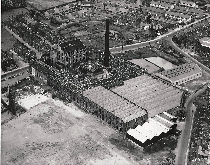
FB380 – Aerial Views, 1955.
Aerial Views – 1955
James Ives & Co Manor Mill is the focus of this image, Kirk Lane runs diagonally across the bottom left corner, Walkers Row leading to Swincar Avenue is on the left of the mill, Manor Road to the right.
B236 – Aerial Views, 1983.
Aerial Views – 1983
Yeadon Dam (Tarn) is towards the top of the view in the centre.
Above it is Leeds Bradford Airport, a runway and terminal buildings are just visible.
To the left the mill chimney is part of Banksfield Dye Works, moving right, in the centre is a cleared area which is the site of the former Manor Mill on Kirk Lane.
Also on Kirk Lane towards the bottom another chimney marks Leafield Mill.
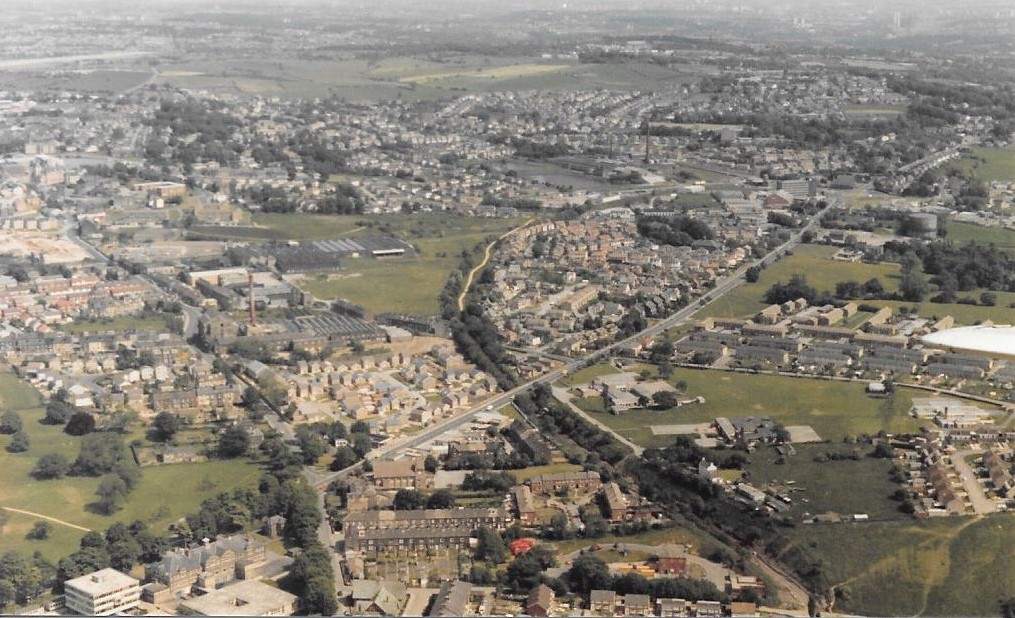
B235 – Aerial Views, 1983.
Aerial Views – 1983
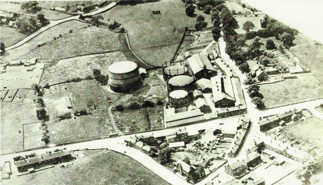
The road running from the top left corner up to the top middle is Apperley Lane.
The garage is JCT 600.
Bottom left is a gasometer, this was Yeadon Gasworks, it is now demolished and housing on the site. (February 2013)
New Road Side (A65) is out of view on the left.
Warm Lane runs from the top middle to the right middle, the collection of buildings in the centre is Greenside Farm, perhaps better known as Emsley’s Farm and Visitor Centre.
U469 – Aerial Views, 1983.
Aerial Views – 1983
June 19th 1983: The photographer and donor of this photo is Andrew Emsley, the pilot of the plane was Alec Webster who owned the Yeadon Flying Club.
Warm Lane runs from the left top corner to the bottom middle of the view, Apperley Lane from the bottom right to the bottom middle.
Greenside Farm is in the centre, to the right is JCT petrol station and car sales, in the top right corner is a gasometer left on the site of the Yeadon and Guiseley Gasworks which was by then defunct.
V147 – Aerial Views, 1983.
Aerial Views – 1983
June 19th 1983: The photographer was Andrew Emsley, the pilot of the plane Alec Webster owner of Yeadon Flying Club.
New Road runs diagonally from the centre right towards the left with the former gasworks to the right of the road.
The line of the defunct Yeadon railway can be seen in the middle, a curving path lined with trees, Westfield and St. Peter & Paul schools are between New Road and to the right of the railway track bed.
Kirk Lane runs from top to bottom (then Dibb Lane), to the left of Kirk Lane Leafield Mill is still standing and in the bottom left corner Aireborough Grammar School.
V152 – Aerial Views, 1983.
Aerial Views – 1983
19th June 1983: The photographer was Andrew Emsley, the plane was piloted by Alec Webster who owned Yeadon Flying Club.
New Road runs diagonally across the centre of the view, to the right of the road is the site of the Yeadon gasworks with a gasometer still remaining.
Across the bottom is the Westfield estate.
Previous Comments:
Re I137, I139 & K242
teleg
I’d like to thank whoever was responsible for this photo of Yeadon in my childhood. It’s wonderful to see the streets where I ran free as a child and the houses where I was born and lived into my teenage years. I was born on the Green in the house at right angles to the “Oddfellows Inn” and lived at times in Howarth Lane, and later in Varley’s Fold and went to the pictures and pantomimes at the Temperance hall. I also went to Sunday School in a room underneath the picture house, when the picture ended we would rush up to Walt Clapham’s Fish shop for a bag of chips or to Machell’s Pea Shop for a plate of peas. Wonderful to see the old shops where we went shopping. Archie Marshall’s fish shop and next door the green grocers, Shuttleworth’s Butchers, Nancy Flesher’s Dress shop, Donny Whites Paper Shop. I can still name all the families who lived in Varley’s Fold and some of the people who lived in Harper Terrace. This has made me very happy. Many thanks Carlo.
26 August 2015.
Re I137
smbork
Wish I could get a copy of this photo. I have just spent time remembering where everyone lived and where we used to play. Only a pity that my house was just off the right hand edge.
It must have been taken in the late thirties / early forties as I remember the houses on “Sandy Way” being demolished. They had balconies ( a great novelty ) overlooking the Temperance Hall. There were so many demolished buildings in that wartime period. It left great places to have dens. What would “Health and Safety ” make of that these days.
16 March 2017.
Re I137
teleg
I too have spent time looking at Yeadon as it was when I was running around the streets and fields in my childhood. The house where I was born and the houses where I and my uncles, aunties, great aunties, grandparents and great grandparents lived and the school as it was then and most striking of all was to see a line of washing strung across the street from my house to my uncle Jack’s house what marvellous memories. Thanks Carlo.
19 March 2017.
Re I153
Comment from our facebook page 26th October 2015:-
Philip Walker. Carlo, I was born in 1947 in Manor Square. At the age 6, I was playing in the rubble of The Cricketers Arms on Ivegate, So that should indicate pre 1953 as the Cricketers is still up on this photo. At the bottom edge of the old Graveyard is a black hut attached to the wall. This was used by the Yeadon Branch of The Royal British Legion, who organised a coronation party which I attended. There was nothing in front of that Hut from the end of Harper Terrace to Ivegate and from the right hand side of the row of terrace houses to Harper Lane was just waste land. The other major features are Wormald’s Yard the Building featured on your Calendar is still up and the houses behind it are still present, they were not there in my early fifties childhood. The other thing to remember is that Aerial photography would have been a novelty for the Yorkshire Aeroplane Club, which did not exist till the mid thirties. I can remember the Shuttle works standing empty with broken windows and the Houses Behind Willow Cottage on Abbey Lane, but the one’s either side of Wells Hill (our Sledge Track) were gone. The long row of terraces backing on to Engine Fields were present and the Council owned waste paper dump at the top of Wells Hill were still up early fifties. I would suggest mid to late thirties for this Photo.
Re D179
Hannah1
The old Yeadon Manor c1600 is left of the large mill building you can still see the house, it still has its garden or part of it. A path runs from Swincar along the left side of the mill complex . The name Manor was used for the streets around it, Manor Square, Manor Terrace, etc. The area in front of it, was the old Yeadon Green, nearly all the old cottages have gone, two cottages that was the old Oddfellows Inn have been converted back and some of the old shops are still there.
14 June 2014.
Re B098
electricalphil2005
When this photo was taken I would be 7 years old and living at No:3 Manor Square, which can be seen just below the Church Institute building. There are 4 cottages, ours was the third from the right.
I was attending South View Junior School and my early years teachers were, Miss Flynn, (Marvellous Lady) Miss Cornish, Mary Denison ( Most Favourite teacher of all time, I learned so much from her lessons), Margaret Wolsey(Hateful bully of a woman), Agnes Parkinson ( Head Mistress, Firm but fair, would not stand any nonsense)
19 April 2013.
teleg
I was born in 1926 at a house which was attached to the Oddfellows Inn and lived for some time in Varley’s Fold which is the brownfield site in the centre right where the flats at Lane Fox Court is now. My wife Margaret Hardy was a Teacher at South View and lived at 14 Harper Lane and later at 1 Ruffford Ridge just off the edge of the picture.
12 June 2013.
jdathebowler
The row of terrace houses bottom right behind the Temperance Hall (The Temp) is Saxton Buildings. I was born at number 7 in 1947. When number 2 became available soon after we moved in there. It was a much bigger house having 3 bedrooms. I lived there until April 1961 when the houses were condemned by the council. We then moved to a brand new council house on Shaw Leys.
16 November 2013
jdathebowler
The large building with the double doors on Old Haworth Lane was Norman Birds garage, servicing and car repairs. The large building behind the Robin Hood Pub was the old Shuttle Works. Just above and to the right was either Abbey Garth or Abbey Fold. Two ladies I think they were sisters lived there, they always wore mob caps. The large house on Well Lane was where my grandmother, my aunt and uncle and my 2 cousins lived. The triangular bit of land behind the black hut bottom right is where Willy Machell set up his scrap yard business.
28 November 2013.
Re M077
electricalphil2005
The building in the lower left corner is the Church institute, in front of that is old Howarth Lane, which runs behind a row of cottages. These Cottages were numbers 1 – 4 Manor Square. I was born at No.4, which was my Grandmothers cottage at the left end of the row and lived for 18 years at No.3 before moving to Queensway. The cottages were the last buildings in Manor Square to be demolished. The new road had already been completed before we moved in 1965.
This photo shows my world and my playground as I knew it as a child and is exactly the way I remember it.
30 June 2013.
Re FB380
KenLee
The isolated cluster of buildings very close to the bottom and right in the middle of the photograph was a Fish ‘n Chip shop – a regular stopping place after we had been to the “Temp” cinema.
04 August 2013.
Re A194
Andyb1960
A forgotten view that brings back happy memories of my days in Westfield school in the mid 1960s. As a child we played in and explored around the house gardens and cricket fields.
I vividly remember finding owl or hawk pellets (bundles of fur and bone ) left in the wheel of the then up turned and rotting cricket sight screen that can be seen in the picture , and excitedly taking them in to school next day to show mr Gouch, who took the time and effort to slowly untangle them and show us what they were and explained how they came to be there some were mice or voles and some birds. I loved my time as a youngster in Westfield school it was such a fun time to be a child in the 60s.
10 June 2014.
Page 1 of 2 More >>
Consolidated by Jack Brayshaw. 11 August 2021.
Last updated: 23 November 2022 – All images reviewed. 16 February 22 – Photo ID: A194 & B064. 05 November 2021 – Photo ID: T67, M077, FB380. 03 September 2021 – Photo ID: B098. 24 August 2021 – Photo ID: D179.